Photo credit: Gary Hughes
White Water Kayaking & Rafting
OVERVIEW
There are numerous whitewater rivers and creeks that are accessible for kayaking and rafting near Auburn. Boaters often paddle hard-shell kayaks, inflatable kayaks, or paddle rafts. The most reliable river close to Auburn, with year-round flows due to dam controls, is the South Fork of the American River. Other rivers with more variable flows include the Middle Fork of the American River and the North Fork of the American River.
SAFETY
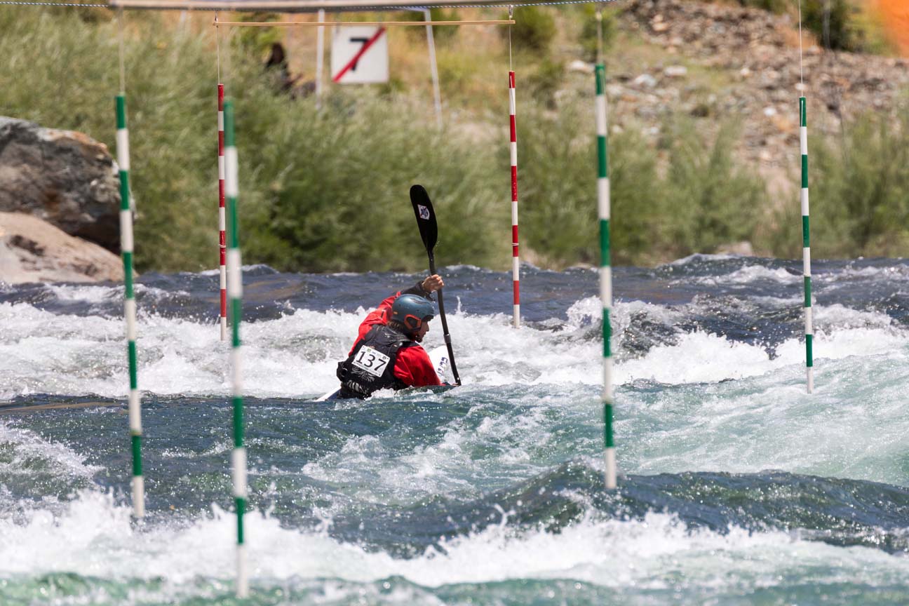
Please be advised that whitewater boating is an inherently dangerous sport: proper professional training should be obtained before attempting this sport. Aside from learning the basics of whitewater boating and whitewater safety, boaters should be very aware of colder water temperatures (and dress appropriately, which often involves wearing a dry suit), and what water levels are unsafe for a given section of whitewatee. Basic gear to have for whitewater paddling includes a suitable craft for the participant’s skill level and section of river to be paddled, a whitewater helmet, a personal floatation device (a lifejacket designed for whitewater), proper footwear, a rescue knife, and a river rescue rope (usually contained in a throw bag). You should always paddle with at least one other boater. Further guidance on river safety can be accessed on numerous sites: consider, for example, https://www.americanwhitewater.org/content/Wiki/safety:start . This American Whitewater link also has a description of the six difficulty ratings for rapids: each river section will have its rapids ranked from Class I (easiest) through Class VI (impassable) using this universal rating system.
LOCAL BEST BETS
The closest-to-Auburn river run is The Confluence-to-China Bar section of the North Fork of the American River, which receives additional dam-controlled input from the Middle Fork (waters usually arriving at the confluence of the North and Middle Forks in the late afternoon). This section only has two or three challenging rapids at regular low-flow conditions. Of note on this section is the Pump Station rapid, created by PCWA: it is an artificial whitewater course which has both waves and holes during low-flow conditions, and is at its best in the late afternoon (when releases from the Middle Fork reach the Pump Station rapids). These rapids have been used several times for Auburn River Festival events, with the latest being held in 2018. The China Bar area is currently open on weekends, until dark (but, these times may vary, so please consult the Auburn State Recreational Area website for details).
RIVER FLOW INFORMATION
The South Fork of the American River has three different sections, varying in length and difficulty, starting from just below the Chili Bar dam (near Placerville): the Chili Bar section, the Cool to Greenwood section (or “C to G” section), and finally the South Fork American Gorge section. The C to G section is the easier of the three sections, and the entire South Fork can be run in a long fun day on the water. Information on the specific difficulty ratings of any of these river sections (and any other rivers and creeks near Auburn) can be accessed on the Dreamflows website (please see the “California West Sierra – Northern“ section of the Dreamflows website). For example, the “North Fork American – at Highway 49 Bridge” details information on where to park to access the “Confluence to China Bar” section of the North Fork that is closest to Auburn. The release schedule for dam-controlled releases to the South Fork that make it runnable in low-rain conditions can be found at http://www.dreamflows.com/Pages/ChiliBarSchedule.php. All sections of the North and South Forks of the American are included in the first Dreamflows web site. This site will also provide the most current river level information, whether the current level is sufficient to kayak or raft (or whether the level is unsafe for boating), descriptions of the rapids and their respective difficulty levels, and links to other useful websites such as that of “American Whitewater” which catalogues additional information useful to boaters.
OUTFITTERS & GROUPS
There are numerous whitewater outfitters in this area that provide both safety and boating instruction, and professionally-guided raft trips for those with limited whitewater experience that want to sample whitewater rivers in the Auburn area. See this website’s Resources page for a list of these. Locared right in Auburn on Lincoln Way is Sierra Outdoor Center . It has used and new whitewater equipment, and can provide helpful guidance on paddling in the area.
The locally-run Gold Country Paddlers is well worth joining for its very low yearly fee. Often paddlers new to the area, as well as those well-accustomed to paddling local rivers, get in touch with each other using a group e-mail list serve that comes with membership. Their website has additional useful information that is accessible free of charge. In addition, a national organization, Team River Runner‘s local chapter (TRR American River Chapter) has a whitewater boating group that paddles the South Fork of the American River and other local runs near Auburn. TRR is focused on health and healing for veterans, current service members, and their families, through white water boating. TRR provides free boats, gear, and instruction to Service Members and their families. They will also provide adaptive paddling gear for those with Service-related injuries. For more information, please contact local representative, Phil Sayre.
Photo credit: CapitalCorridor.com
Boards & Flat Water Boating
The Auburn area also has many opportunities for those who want to do lake paddling. Watercraft suitable for lakes include stand-up paddle boards (SUPs), recreational kayaks, and canoes. Power boating and water skiing locations are also available. Two options near Auburn for boating listed here are the same as those available for open-water swimming.
LAKE CLEMENTINE, Auburn State Recreation Area
Webpage – This is a 3.5-mile-long lake just upriver from Clark’s Hole. Lake Clementine terminates at the Clementine Dam, which can be accessed from the Lower Lake Clementine boat ramp area (map coordinates here). An ASRA parking pass is necessary to park near the boat ramp at Lake Clementine. A primitive path can be accessed that begins behind the Marina Host’s trailer, and runs along the lake. A small gravel and clay natural beach can be reached less than 10 minutes walk from the Marina Host’s trailer. From this point, you can swim away from the Clementine Dam, toward the upper part of the Lake. Do not begin or end a swim in the boat ramp area. Lake Clementine is narrow, with a fair number of water skiing, and other power, boats. Please exercise caution by swimming quite close to the shore. It is a deep lake, making this possible. Lake Clementine remains quite chilly into the early Summer, so please be very cautious, and wear the appropriate thickness wetsuit and cap when needed. Click here for ASRA additional details.
ROLLINS LAKE, Colfax
Webpage – Only about 20 minutes off of I-80 at the Colfax Exit, is this reservoir suitable for flat water activities.
FOLSOM LAKE
Webpage – This is a much larger lake, relative to Lake Clementine, and is heavily used also by powerboats and jet skis. Folsom Lake usually warms more quickly in the early Summer than Lake Clementine. The lake also varies in water levels, depending on rainfall and how much water is released from Folsom Dam. Different levels will result in various bottom features and shore plants being either covered or exposed. With its average of 75 miles of shoreline, there are numerous locations to swim.
The closest access point to Auburn is in the vicinity of Rattlesnake Bar boat ramp. From Rattlesnake Bar, open water swimmers can either swim up or down the shoreline. Please do not start swimming right at the boat ramp; rather, please walk either up or down shore to start swimming and avoid the boat traffic in the ramp area. There is no cordoned off area for swimmers. Please, as with Clementine, stay close to the shore in this narrow reservoir to avoid interactions with powerboats. The Auburn Triathlon usually holds it swimming leg in Folsom Lake, starting a Rattlesnake Bar (during events like these, this section of the lake is closed to power boats).
There is a designated swimming area at Beal’s Point in Granite Bay: it has an area cordoned off, keeping boats separated from swimmers. You will need a California State Park Pass to access Beal’s Point.
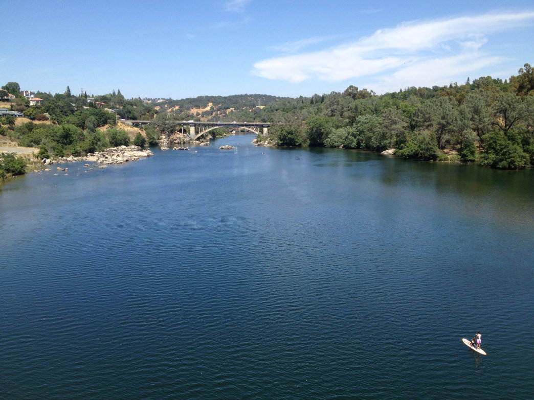
LAKE NATOMA (pictured above)
Webpage – This lake is connected to Folsom Lake, and is a pleasant place to do flat water boating or SUPing. Power boats are not allowed in this lake, so it’s a good wake-free area for beginning flat water paddlers. A convenient location to launch from is Negro Bar (map).
CAMP FAR WEST RESERVOIR
Webpage – This Nevada County reservoir is accessed from Auburn by traveling some back roads. The route from Nevada St at I-80 via Hwy 193 takes about 45 minutes. Activities include camping, swimming, boating, water skiing, jet skiing, hiking, biking, fishing and horseback riding.
PRIVATE LAKES
Lake of the Pines is a 20 minute drive north of Auburn on Hwy 49 fro the I-80/Hwy 49 exit. Lake Combie is in Meadow Vista and it can be accessed from the Meadow Vista exit off of I-80, but also from the Lake of the Pines. These are examples of lakes accessible only to property owners within the general area of the lakes. If you know a home owner, they can grant you guest access.